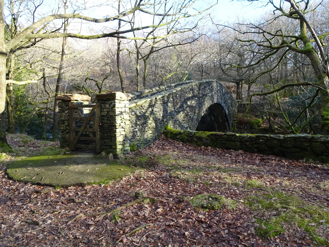
Seathwaite Memorial Bridge or Wallowbarrow Woods Footbridge if you prefer.
I saw a reference to ‘the magic symbol engraved on the Seathwaite Footbridge’ the other day – in the Duddon chapter of Robert Gambles excellent book “The Story Of The Lakeland Dales”. I was instantly intrigued because I thought I knew my footbridges around Seathwaite, having crossed them probably hundreds of times, and never seen any such symbol. So that decided our exercise for the day. The quest to find the magic symbol and complete the walk by way of Wallowbarrow, Grassguards and back down beside the River Duddon through the impressive rift of Wallowbarrow Gorge. This wasn’t a difficult decision because this walk is probably one of the best low level outings in the Duddon, the Lake District, and therefore the World!
The first question was to which footbridge is Gambles actually referring. The main footbridge, over the Duddon itself, has a plaque but it is wholly factual rather than magical. And I suppose this bridge, although unquestionably only a footbridge and often referred to as ehe Seathwaite Memorial Bridge, is rather a long way from Seathwaite. So could it be the little wooden footbridge over Tarn Beck. A look around its woodwork and supporting stanchions, eliminated that as a realistic possibility.
So it must be the Memorial Bridge. The plaque on the upstream internal parapet wall west bank didn’t give any clues. So I was a little baffled and about to conduct a more detailed search when Deborah, and her sixth sense for these things, spotted the other two. Sure enough one was definitely magical or masonic looking. An amazing thing, beautifully carved in slate. The was other was simper, two letters only in a perfectly flat rectangle of slate, but again it was beautifully carved in a style that matches the easily seen aforementioned plaque.
Having found them confirmed that Gambles, as usual, was spot on with his information. Though mystery sill remained – what was the meaning behind these two hidden plaques and indeed behind the visible plaque? I’m no expert on magic or masonic symbols and even after consulting with a few people who are, and searching the internet, I was no wiser. How intriguing. It was Deborah, again, with her museum curator’s expertise, who searched deeper and found the answer which had been posted by the Duddon Archeological Group (a remarkable body of enthusiasts who have done much to trace the Duddon’s rich past history stretching back into pre-history).
The captions to the photographs tell all – apart from the actual locations of the two ‘hidden plaques”. So find them for yourself, it’s more fun, but mums the word – keep it a secret!

One hidden plaque is engraved with ‘the magic symbol engraved on the Seathwaite Footbridge’. It actually translates thus: the Greek letters alpha and omega are intertwined with a star which represent the initials of Aida (Deborah) Borchgrevink – her maiden name was Starr.

The other hidden plaque has Aida’s initials (AB). The bridge was built in memory of Aida Borchgrevink – an opera singer and sometime resident of the valley in the early years of the last century. She was born Aida Starr in Ohio in 1861 and died in 1931 and was someone memorable enough to have a bridge fashioned in her name. She obviously lived an intriguing life and was fortunate enough to reside in this most magical of all Lakeland Valleys – wouldn’t it be great to know more about this person.

Wallowbarrow Woods west of the bridge – here lies the real magic. I once wrote; ‘If there be elves, they live here, in these woods’.

The visible plaque telling that the Seathwaite Memorial Bridge was built by W Grisenthwaite for AF (Aida’s daughter – Aida Louise Borchgreink) and R A F (presumed to be Aida’s son in law). It is thought that Grisenthwaite was a monumental mason from Penrith who also did the similarly styled high quality carving.

6th January 2021 | HELM CRAG AND BEYOND
I look out to Grasmere’s Helm Crag from my bedroom window – lucky me. The thing is I really do appreciate it. Every day is different but I get a particular buzz when I open the curtains in the morning and the fell has been transformed by the first heavy snows of winter. Helm Crag looks like it’s wearing a suit of shining white armour. All except for the scattering of steep crags and coxcomb ridge of rocky spikes that is. These stand stark black against the white because, under most conditions, they are too steep to hold the snow.
On this day much of initial snow covering had disappeared from the lower heights. Apart from smears of ice and patches of snow the colours, of rust red bracken and green grass prevailed, contrasting vividly with the still white shining domes of the higher fells. These heights being Helvellyn, Seat Sandal and Fairfield to the west, Tarn Crag, Codale Head and Ullscarf to the east.

Descending into Far Easedale – which came first the magical Hawthorn bush or the boulder?
Taken at 3:12pm.

Band of gold, reflections by Stythwaite Steps Bridge.
Taken at 4:02pm

Deborah by the summit cairn of Gibson Knot – Ullscarf seen beyond.
Taken at 2:38pm.

Looking to the ‘2nd’ Lion Lamb formation – see “THE GRASMERE YEARBOOK” for clarification. Dunmail Raise to the ,right.
Taken at 1:46pm

Looking from the nose of Helm Crag east to Seat Sandal, left, and Fairfield, right.
Taken at 1:28pm.

Looking from the ascent of Helm Crag – west to Tarn Crag and Codale Head with Deborah and Pooks in the foreground.
Taken at 1:04pm.

16th January 2021 | EASDALE TARN AND LANGDALE EDGE
There was plentiful ice in the valley and though it was a dull day with low cloud I suspected there would be plentiful fresh snow on the heights. So why not have a look at Easedale Tarn and if possible strike for the heights of the “Langdale Edge”. Having mislaid my slip-on crampons, and unwilling to don my heavy duty climbing boots and crampons, I was rather worried about ice on the paths. Last time I was up the path to Easedale Tarn the tiny wooden footbridge on the path opposite Sourmilk Gill Waterfall looked innocent but was lethally slippery and clad in verglas. Thankfully a chap, who was making descent, and had already crossed it, gave us due warning. here was plentiful ice in the valley and though it was a dull day with low cloud I suspected there would be plentiful fresh snow on the heights.
This time the ice, although frequent, was passable with care and use of my titanium spiked stick (walking pole). Sure enough Easedale Tarn was frozen and snow clad. Just on arrival a glimmer of blue gave thought to ascend to the “Langdale Edge”. This was facilitated via a little corridor, below the flanks of Looking Howe and Great Castle How, up to the main path traversing below Little Castle How. The stone rings though snow clad were just discernable as was the ancient highway leading over the fellside to overlook Great Langdale.
The snow high on the edge was a good 125mm deep, A pleasant shock then, that because it was uncrusted and unconsolidated, and still fresh and hardly changed since when it fell as unblown flakes, it was a joy to walk through. I only fell over once, slipping on a rocky slab hidden below the surface, and it required minimum effort even for uncramponed feet. I had to marvel at the Herdwick’s though. Carrying on undaunted, hoofing away to get at the minimal grass below, with snow hanging from their fleeces and blobbed on their noses. I told them to get down before nightfall but they just looked at me painfully replying: “Lol, shut up Bill, we are the experts here.”
Cheeky rascals. The views into Great Langdale, with clouds hanging below the heights around the head of the valley, were dramatic. As was the view over Grasmere lake before descending the Silver How shoulder, over Wray Gill, to Pass Allan Bank and make return to the village. Very pandemic quiet.

Overlooking Gurt Langel.

Herdwick in the snow.

The Langdale Edge.

Easedale Tarn, iced over and snowclad.

Snow clad rowan on Looking Howe,

Looking north to Easedale Tarn below Tarn Crag.

22 January 2021 | WASDALE
The mountains had been in thick cloud all day, snowing on the tops, but then in the late afternoon the sun briefly broke through.

The sun makes an appearance over the foot of Wastwater to the west.
Taken 22/1/20 at 4:39pm.

A blast of light illuminates the road leading to Wasdale Head.
Taken 22/1/20 at 4:03pm.

The clouds break as the sun goes down.
Taken 22/1/20 at 4:08pm.
 over the Carrock Fell’s hill fort’s defensive wall to the Skiddaw Massif, Knott, High Pike and over the Solway to the Scottish Hills. Taken at 2:44pm.")
24 January 2021 | CARROCK FELL
Snow and ice on the fells, sunshine and clear blue skies – another heaven-sent day in the Lake District. Deborah remembered a path she had once used rising from directly up the southern flanks of Carrock Fell. It started close by what was once an ancient trackway, now overgrown and hardly discernable, a little way up the Caldew Valley road. Unfortunately, the trackway soon disappeared into a great swathe of gorse and we never found the path. Undaunted hands and knees crawling managed to pass this first obstacle. Only to be followed by endless banks of the thickest heather imaginable. But finally, we emerged onto the shoulder, by the Mosedale Cairn, and found a path proper leading up the heathery shoulder and its ever-thickening mantle of crisply frosted snow.
The climb to the top of Carrock Fell, its summit ringed by the iron age defensive wall, revealed a world of breathtaking beauty. A perfect winter’s day, with sunshine, clear skies, and not a breath of wind. The views, stretching uninterrupted to all points of the compass, showed The Northern Fells, sculpted in brilliant white snow, at their pristine winter best.
Walking on the inclusion of High Pike was followed by a high traverse to the remote and recently restored Lingy Hut. Hats off to the Mountain Bothies Association because the hut, open to all, is in tip-top condition. Please fellow mountain people value it and keep it so.
From the hut, descent leads easily to pass the now deserted Tungsten Mines below Brandy Gill. Then, back to the road leading down the remote and wonderful Caldew Valley. Fond memories of Chris Bacon, in 1980 in charge of the exploratory tunnels of the then working mine complex, who let me detonate a charge before telling me we had only a few minutes to climb ladders skywards to escape the poisonous fumes of the explosion. Especially challenging with a broken wrist in plaster. What larks!
Walks to all the tops in the Northern Fells are described in my COMPLETE LAKELAND FELLS (currently out of print – but boy would I like to publish it again). Carrock Fell will be found in my NORTH O’SKIDDAW GROUP of fells.
.

View up the Caldew Valley to the shoulder, in ascending order, of Coomb Height, Rigg and the high point of Knott.
Taken at 1:22pm.

Lichen in the heather.
Taken at 1:28pm.2pm.

Frost crystals growing from the snow in the heather.
Taken at 1:46pm.

Descending into the Caldew Valley with Bowscale Fell to the right.
Taken at 4:26pm.

Approaching the summit of Carrock Fell.
Taken at 2:40pm.

Frosted summit rocks Carrock Fell.
Good enough to eat!
Taken at 2:42pm..

The Lingy Hut, high in its remote setting.
Taken at 4:26pm
So many magnificent photos, so many memories. My life has been in the fells of Langdale. Lived first in Grasmere, then a move south to Ambleside. Now living with my dear wife Lisa in Underbarrow. Over 80 now, so it is all the more exciting to view your pictures.
How did I come across your contribution? I was following your account of Aida Borchgrevink and her memorial bridge. Hope now to visit the Bridge. Our son frequently drives in the Duddon area. Many thanks. Peter P.S. I am fluent (ish) in Norwegian and study war-time conditions in Norway.